Garmisch-Partenkirchen to Mittenwald, Take 1
Between the conference and WWOOFing in Norway, I had a little less than a week of alone travel time. The morning after the conference, I took the first train I could out of Munich (marked 1 on map below) to the Alps on the German-Austrian border (3 on map). For (my own) reference, I labelled Starnberg (2), because that’s where my professor took us that day we skipped part of the conference together. A couple days later, I would take the train to the end of the line at Innsbruck, Austria (4).
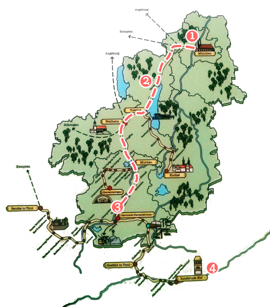
Specifically, the town I visited is Garmisch-Partenkirchen, which, according to my research is a great skiing place in the winter and a great hiking place in the summer. I had already picked out several hiking routes to take. I had two goals for the 3 days I will be here:
- Hike from Garmisch-Partenkirchen to Mittenwald.
- Reach the summit of a mountain.
But, aware that I am completely at the mercy of the universe and such (in terms of the weather, health etc.)…
I’ve learned that anytime I refer to a desire as “my goal”, it’s really just an arrogant way of saying “my request to the universe”.
We will revisit these goals later.
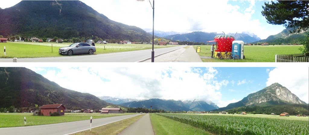
My AirBnB was actually one train stop away from Garmisch-Partenkirchen proper in a little town called Farchant. The walk from the train stop to my AirBnB was already breathtaking. Notice, the adorable little old man buying strawberries from an adorable little shop in the middle of freaking nowhere. This place is so lovely.
After dropping off 70 days worth of luggage (which included a strange combination of farming equips and conference equips!) at the AirBnB, I got straight to work on goal #1.
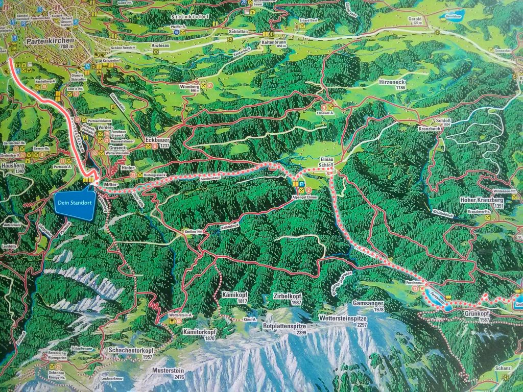
I wanted to walk through Partnachklamm gorge, past Elmau, to Mittenwald (see proposed route below). Mittenwald is on the German side of the German-Austrian border and it is supposed to be super quaint, according to my research. Google maps is terrible with GPSing and generally showing what trails there are. So I took a picture of the trail map posted at the beginning of the trail to help me navigate. Silly me was so confident that I would go towards Mittenwald, that I didn’t even bother to take a picture of the map of the west side of the map …
I walked through Partnachklamm gorge which was nice and all, but it’s a bit on the touristy side. You can search up any other blog that wrote about it and, if they went in the summer, that’s probably an accurate depiction of my experience there.
At the place labelled “Dien Standort” on the map, I encountered issues. There were multiple routes to Elmau, but all of them were blocked with signs in German and such. When I translate the signs, I got results such as: “CLOSED” “WARNING” “CAUTION” “AT YOUR OWN RISK” “DANGER” “NO PATH TO ELMAU”.
As an aside, the translation app on my phone I use is pretty awesome. I can hover over signs on my camera and instantly see the translation like this:

As you can see, the translation isn’t perfect, and sometimes I have to rotate the camera around to tease out relevant words; still it’s so much better than nothing at all.
And yes, I had apple sauce for dinner. Don’t judge me.
Back to my plight at Partnachklamm. I was determined to accomplish goal #1 and strongly considered going through the path despite the warnings. But storm clouds were coming in. I remembered my loved ones at home. I thought of how stupid it would be to die here.
I sighed and took this as a sign that the universe is declining my request to go to Mittenwald today. Obediently, I turned away from every path that represented my goals and aspirations, and I took the only unblocked path (that wasn’t the path I came from) — towards the west.
Now, remember how, in my arrogance, I only took a picture of the part of the map I intended to walk to?
Well, as I continued west, I walked off the boundaries of the only map I had. I expected there would be other maps or pointers along the way. But there were none.
Remember how I said the storm clouds were coming in?
Thunder rumbled in the distance now.
I continued walking until the path diverged. There was one path that I knew was headed towards the city and one side that continued to who knows where. In my heart, I had this desire:
“Seeing as I won’t accomplish goal #1, perhaps if I keep walking I’ll accomplish goal #2!”
So I turned away from the city and went on, map-less and ambition-full. Meanwhile, the clouds, rain-full, beckoned. The concrete path became a rocky path. The rocky path became a dirt path. The dirt path led me into the woods. It was pretty flat, windy, and dragged on for a really long time.
In contrast to Partnachklamm which hosted almost too many people, there was absolutely no one here. It was eerie. The only thing that could be considered a “sign of humanity” was an abandoned glove at the side of the trail. The thought of the glove’s owner plagued me the entire time. Did the glove owner encounter something here and die? Did the glove owner commit suicide here? Is there a serial killer here? IS THAT WHY THERE IS NO ONE ELSE??? Truly, it is better not to have any signs of humanity than “signs of humanity” like these.
There aren’t any blog-worthy photos here of this stretch. The path just kept going downhill so there were just trees everywhere (which was lovely and atmospheric, just not photogenic). The rain, as light as it was may have been as persistent as I was. It washed out the saturation in my field of view as well as my will to take pictures. The thunder went on and off; as if to remind me of my place in the “natural order” of things, as if responding to my inner monologue of summit-climbing glory. There were also no more diverging paths. At every instant an inner demon (or my mom) nagged me to turn back. It didn’t seem like I would be in any position to accomplish goal #2, but I wanted to at least see this trail to its end.
Eventually, the path through flat land, low-lying lands started to rise. This is what it looked like as the path rose above the valley. The thunder seemed to have subsided, and the rain either stopped or I just became numb to it.

Around this point, I hear a rhythmic squeaking and creaking.
ACTIVE CABLE CARS!
I rejoiced, these are signs of humanity I can rely on. Not only will this trail end, but it’ll end at the submit of some mountain on which I can take a cable car back to the city. And i would INADVERTENTLY ACCOMPLISH GOAL #2 IN THE PROCESS. It would actually be so perfect. With renewed vigor, I climbed.
Not long after, the clouds came back, darker and more decisive than before. And rumbled,
“Have I not been warning you to turn back?”
“Hey, how about you hold off the storm for a couple minutes, let me reach the cable cars at the top and I’ll be forever grateful–“, I bargained.
“–No.” It responded immediately, blacker and sterner than ever. The message was clear.
Still, I went a little further, squatted by a tree, hoping to wait it out. I knew that I could have pressed on if I weren’t alone. I knew that weather patterns are bound to be more unstable around mountains. If I let weather get in the way of me and the summit, I would never get to finish goal #2! And then the thought of being at the top of a mountain during a thunderstorm, and how unfair I am being to those that care about me, again beat sense into me. (I also couldn’t remember whether you are supposed to seek refuge under trees or completely stay away from trees during a thunderstorm.)
Dejected, I turned and went back the way I came from.
The thunder continued to ushered me out, as if knowing I would turn back if it stopped. (Honestly, I would have!) I went back through the wooded low-lands, past the serial killer’s victim’s abandoned glove… pathetically singing this on repeat to comfort myself:
Who made the mountains, who made the trees
Who made the rivers flow to the sea
And who sends the rain when the earth is dry
Somebody bigger than you and I
The dirt path ended, then the rocky path ended, and then I was back at the diverging paths. This time, I took the path to civilization.
By now, the rain had stopped and the sky, blue. Of course, the weather clears up after I came back down.
One can weave what happened into a narrative of cosmic (dis)obedience–and I do keep that possibility in the back of my mind. However, as I mentioned, statistically speaking, unstable weather systems are more likely to aggregate around mountains… so my experience is likely not unique to me. Anyway, you are free to interpret as you may without my judgement.
I passed by a cafe that was closing. The cafe’s last customers sitting outside–the first humans I saw in hours–took notice of my aimlessness and directed me towards the city.
Finally, I returned to the beginning of Partnachklamm. This time, I took full advantage of the map.
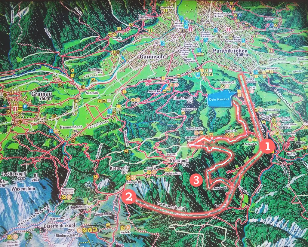
What happened after I got blocked from (1), I was forced into a trail called Bodenlahntal. (Later, I investigated “Bodenlahntal”. It translates to “Ground Floor Valley”. Pretty accurate, I must say.) Notice how close I was to the summit of Kreuzeck at (2), notice how, though I never saw it, there really was a cable car above me! After I turned back, I went back to the city via path (3). “Dein Standort” was where I was when I saw this map, obviously.
And so, I went back to my comfy AirBnB,
Ate my apple-mango applesauce…
And dreamed of the universe answering all my requests demands tomorrow.